 Saugerties is blessed to have the Esopus Creek running through it. The Creek is a 65.4-mile-long tributary of the Hudson River (which borders Saugerties). It drains the east-central Catskill Mountains in New York. From its source at Winnisook Lake on the slopes of Slide Mountain, the Catskills' highest peak, its flow includes a segment into and then out of the Ashokan Reservoir. (The Ashokan Reservoir was created in 1915 by the construction of 5 ½ miles of dams and dikes within the Esopus Creek drainage.)
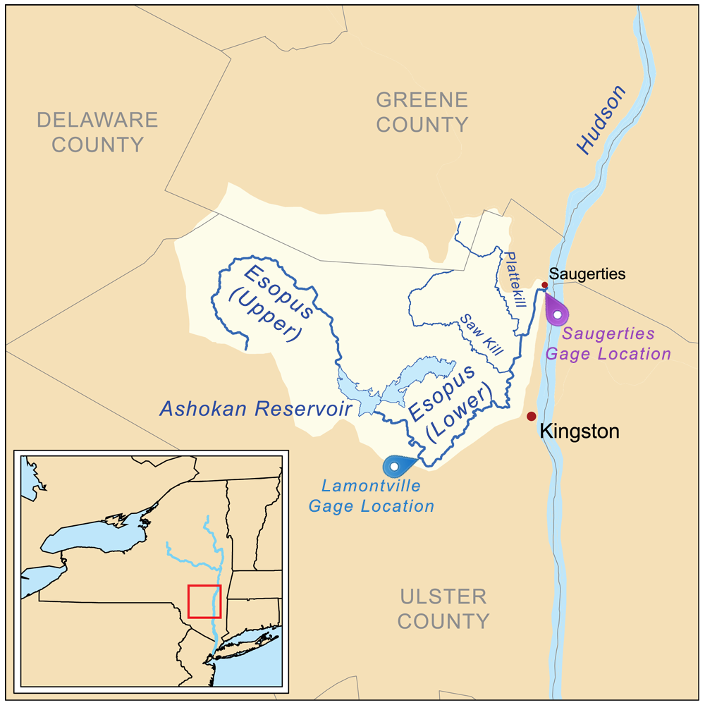
As it flows from the Ashokan Reservoir, the Creek runs through Kingston and then Saugerties, where it empties into the Hudson River. The map (below left) shows the full path of the Esopus Creek. The upper Esopus is above the Ashokan Reservoir and the lower Esopus is below the Ashokan Reservoir. [Click on the map to see a full-size image of it.]
If you have 32 minutes or so to spare, you can take a look at this informative video about the lower Esopus Creek:
Due to Esopus Creek's flow and especially because of the Ashokan River controlling the flow, through occasional water releases, many of the local residents along the Esopus Creek's path are interested in the Creek's water level and its turbidity (the cloudiness or haziness of a fluid caused by large numbers of individual particles that are generally invisible to the naked eye, similar to smoke in air. The measurement of turbidity is a key test of water quality. Fluids can contain suspended solid matter consisting of particles of many different sizes).
This page is for anyone who wants to have an awareness of the water levels as they are measured in various Creek locations as well as providing some information about turbidity. It can be helpful during times of heavy rainfall and/or reservoir water releases, for awareness of the Creek's level versus the listed flood stage level.
Our thanks to Mary McNamara for pointing out the information for this page. For any questions you might have about this page, you can contact Mary at marywaterbyrd@gmail.com.
The 4 images below are buttons that you can click on to get to real-time water measurements.
Notes:
- The images below were from a snapshot of the 4 target websites. For real-time data, please click on the image with the information you're after, and you will see the real-time data.
- The Esopus Creek image on the right and map above are from the Wikipedia page about the Esopus Creek.
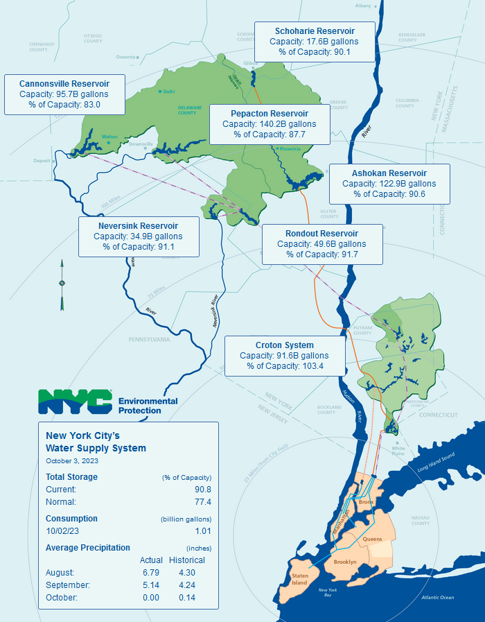
DEP Daily Reservoir Levels. This data is updated daily and shows percent
of capacity at NYC's Water Supply reservoirs. (Including the Ashokan.) Click
on the above button, then on the "View Current Releases" link.)
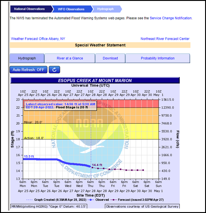
National Weather Svc. - Esopus Creek level (vs. flood stage). This real-time data shows
whether or not the reservoir is full or not and if it is spilling. (Click on the above button).
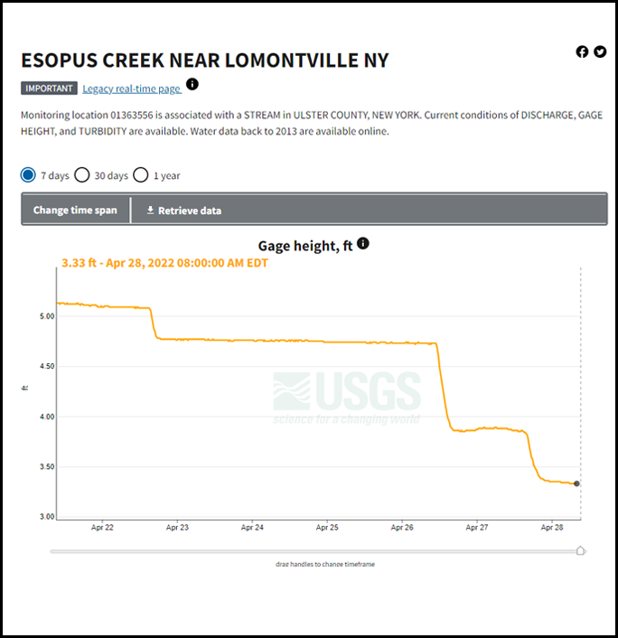
Esopus Creek water levels recorded near Lamontville, NY. The
snapshot image above shows gage levels, but both flow information and
turbidity information is available as well. (Click on the above button, then
on "Next Generation Monitoring Location Page" link.)
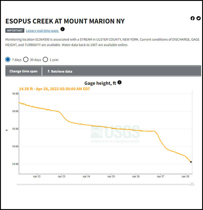
Esopus Creek water levels recorded at Mount Marion. The snapshot
image above shows gage levels, but both flow information and turbidity
information is available as well. (Click on above button, then on "Next
Generation Monitoring Location Page" link)
|
Water Keeps Time
A 32-minute, 27 second video covers the history and the meanderings of the lower Esopus Creek, and its impact on Saugerties throughout history. Directed by Katie Cokinos and Guy Reed. Videography and editing by Alex Rappoport. Original music by Carl Mateo. Video drone operators: Michael Nelson and Sikena Barley. Funded by ShoutOut Saugerties (Susana Meyer Creative Arts Award).
|
|
A Journey Through Lower Esopus Creek
A 52-page PDF. If you want to view this document in a convenient page-turning mode, click here.
|