
To travel back in time, hover your mouse pointer over the image above (taken in 1996 by Ed Poll).
You'll travel back in time to 1905, when Richard Lionel DeLisser snapped a photo from the same perspective.
For questions or input about Saugerties history, please contact Audrey Klinkenberg, Town of Saugerties Historian
Address: 22 Louis Ave.
Saugerties, New York 12477
Phone: 845-246-8329
E-Mail: genie2@hvc.rr.com
On April 27, 1677, New York's Governor Andros signed an agreement with the Esopus Indian Kaelcop, chief of the Amorgarickakan Family, to purchase the land, which is now Saugerties. The price was a blanket, a piece of cloth, a shirt, a loaf of bread, and some coarse fiber. A stream called Sawyer's Kill, where Barent Cornelis Volge operated a sawmill between 1652-1663, roughly identified the northern boundary. The Indians called Volge "The Little Sawyer" and the area became associated with the Dutch word for this title. Volge eventually sold his property to George Meals and Richard Hayes. A mill was established about half a mile west of Volge's site around 1750
In 1710, one of the largest eighteenth century migrations of European people to America took place. Three hundred families from the Palatine region of Germany sailed 110 miles north on the Hudson River, and established camps on the east and west side of the Hudson in October of 1710. The camp on the west side of the river became known as West Camp in the Town of Saugerties. The camp on the east side of the river became known as Germantown. In 1998 the PALATINE MONUMENT was erected on the lawn of St. Paul's Lutheran Church in West Camp. The monument contains a listing of all the heads of families that arrived in the camps. The following words preface the list of names:
KNOW O TRAVELER, within sight of this hill on October 6, 1710, led by the Rev. Joshua Kocherthal and the Rev. Johann Frederick Hager, there arrived on the East and West shores of Hudson's River nearly three hundred families of refugees of the Palatine region in Europe, who suffered many sorrows in the ravages of war, sickness, poverty, and destitution, yet survived to settle these shores, sustained by their faith in the Lord and the sympathy of Queen Anne of England, whom they came to serve in the reduction of the pine forest for naval stores for Her Majesty's fleet. Do you wish to know more? Seek out their names on this tablet, on the pages of history their deeds.
Many descendants of the Palatine families live in the area today.
Prior to 1712 the main business interest in Saugerties was in the Hudson River landings and the ownership of roads by which one could control traffic and gather tolls. John Woods (1717) and John Persen (1712) were two early mill owners. There are indications that many more leased mill sites lined the banks of the Esopus. The mills proliferated to accommodate timber being harvested from the land new settlers were clearing.
Some of the more prosperous early settlers began to build stone houses in Saugerties. John Persen built the Mynderse House around 1685 and Persen built an early gristmill and sawmill in the area and ran a ferry across the river.
The Kiersted House on Main Street (1727) was built by Hiskia Dubois. The Kaatsban area located northeast of the village was settled about 1730. By 1732 the Palantine and Dutch settlers petitioned to deed Kaatsban to the Dutch Reformed Church and build a stone church. This church, which still stands today, became a landmark on Colonial American maps along with centers of population.
SAUGERTIES: A TURNING POINT IN THE AMERICAN REVOLUTION
A BRITISH SQUADRON LAY AT ANCHOR HERE OCTOBER 18-22, 1777
After burning Kingston, New York, on October 16, 1777, a British squadron under orders from Sir Henry Clinton continued north on the Hudson River to this point. The force included 1,700 men from the 7th, 26th and 63rd Regiments under Major-General John Vaughan. The ships, led by Captain James Wallace of the Royal Navy, included the Friendship, the brig Diligent, the galleys Spitfire, Crane and Dependence, and smaller armed vessels and transports. Raiding parties burned Clermont and Belvedere on the east side of the river, homes of Margaret Beekman Livingston and Chancellor Robert R. Livingston. Also burned were sloops in the Esopus Creek at Saugerties and several homes and barns on the west shore. Here General Vaughan learned that General John Burgoyne had surrendered his army at Saratoga on October 17. On October 22, 1777, the British fleet departed, never again to threaten the Mid-Hudson Valley.
In 1832, bluestone was quarried in nearby Toodlum (now Veteran) and a powder mill was established on Fish Creek. Another bluestone community, the Hamlet of Quarryville, is also the home of one of several one-room public school houses built in the late 1800's - The Old Quarryville School House.
As late as 1811 the hamlet of Saugerties contained only twenty-one houses. In the 1820's Henry Barclay sparked the expansion of the community by establishing the Ulster Iron Work and a paper mill.
Mr. Barclay had journeyed to Saugerties in conjunction with the ceremonies for the opening of the Erie Canal. Barclay determined to build a planned industrial community and formed a partnership with Robert L. Livingston to develop water-powered industries on the Esopus Creek. Mr. Barclay's dam with its serpentine waterway eventually powered the largest collection of water-powered machinery in the world. The dam was built by experienced builders who they contracted. (The D&H Canal was being constructed around the same time, and the dam was built by experienced crews from the recently completed Erie Canal.)
Barclay hired John Simmons of Deerfield; Staffordshire, England to manage his new iron works. Mr. Simmons developed double puddling, hoop making, and cold-rolling processes right here in Saugerties. The village grew quickly and in 1831 incorporated under the name of Ulster, changing the name to Saugerties in 1855. Before the Civil War the iron works processed pig iron and scrap, and employed three hundred people working round-the-clock shifts. Manufacture of paper, calico prints, white lead and paint, and shipment of hides helped support the community and created a business district. Typical nineteenth century tradesmen lined the streets above the docks and mills. When the early industries failed after mid-century, paper, brick making, gunpowder, farm goods, river ice, and especially blue stone from area quarries, replaced them. Two thousand-men were employed at one time in quarrying, dressing and shipping about one and a half million dollars' worth of blue stone annually from Glasco, Malden, and Saugerties. The blue stone was used for curbing and paving, crosswalks, door sills and windowsills and much of it found it's way to New York City. The Ulster White Lead Company at Glenerie produced nine hundred tons of lead each year.
The village population stabilized at about 4,000 around 1870 after forty years of sharp increase and remained almost unchanged for one hundred years. Irish, Germans, and later Italians established themselves as workers in the mills, quarries, and brickyards as well as in the village. Later in the nineteenth century Saugerties became a popular landing and hostelry for tourists going to boarding houses I the Catskill Mountain foothills.
Its location on the Hudson made Saugerties ideal for harvesting ice from the river. The ice industry thrived during the 1880's to 1900's. Icehouses were located in Glasco and Malden. Ice was also harvested on the Upper Esopus and on the Sawyerkill.
The brick industry grew in the 1880's when Washburn Brothers and Empire State Brick Company opened their brickyards. Later the Staples and Hutton Brickyards were established.
On February 7, 1891, the Electric Light and Power Company of Saugerties turned on electricity for the first time.
The Orpheum Theater, built by J.C. Davis in 1908, was a center for vaudeville acts, movies, roller-skating, and basketball. The Opera House, now the site of the M & T Bank, offered stage productions and classical performances. Public dances were held there and at the Seamon building, which is now the Furniture Mart. Vaudeville gave way to movies in the 1930's and the Orpheum Theater became the only movie house in town.
The Martin Cantine Paper Company of Saugerties perfected the process of manufacturing coated papers. The quality of its paper was recognized the world over. In 1903 the company took over the Ulster Iron Works property at the falls in the village of Saugerties. From 1888 to 1968 the Cantine Company was one of the major industries in Saugerties. The Cantine family donated the Cantine Recreation Complex to the town.
The Hudson River was the major water route from New York City to Albany. Saugerties shared in the benefits offered by the river and the Esopus Creek, which flows into the Hudson providing docking facilities for passenger and commercial boats. The C. Vanderbilt was the first Steamboat to ply the waters between Saugerties and New York City. By 1830 the village warranted a steamboat line; a night boat for freight and one for passengers to New York City. The steamboat Ansonia (later called the Robert A. Snyder) began its services in 1865 and remained on the Hudson for sixty-five years. Henry L. Finger, Robert A. Snyder, James and William Maxwell, and John and George Seamon incorporated the Saugerties and New York Steamboat Company on January 29, 1889. The Shenandoah renamed the Saugerties in 1889, and the Ida were also major steamboats from Saugerties. Railroad transportation came to the area in 1883 with the opening of the West Shore Railroad of the New York Central Railroad, which served people going north to Albany and south to New York City.
Historic, Detailed Map of Saugerties
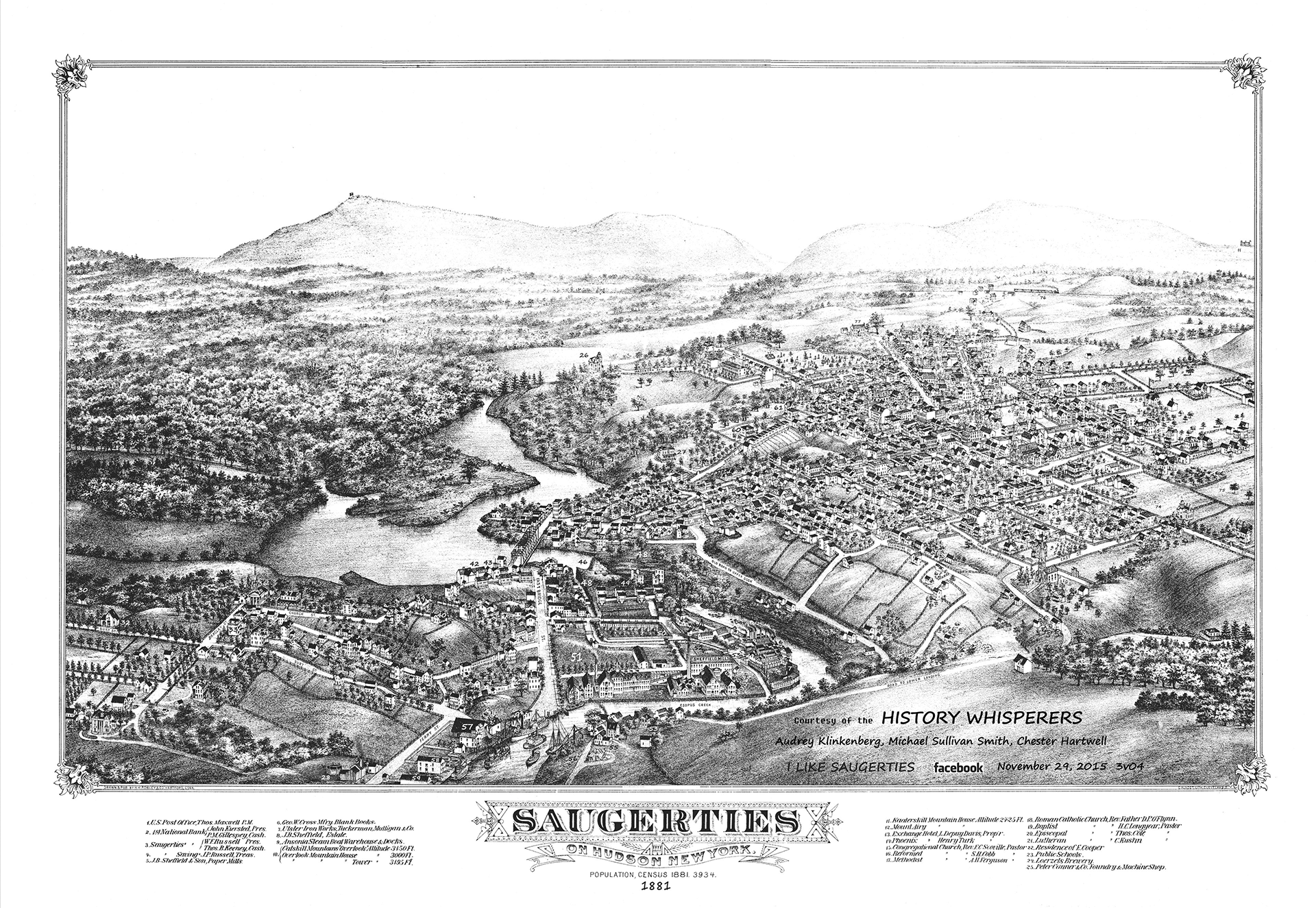 Click the image on the left to see a detailed map of Saugerties (with indexed explanations of points of interest) drawn and published by H. H. Rowley of Hartford, Connecticut, with a number of interesting, numbered points of interest called out. Also indicating that the population at the time of publishing (1881) was 3,934. Map courtesy of Audrey Klinkenberg, Michael Sullivan-Smith and Chester Hartwell. For other views and maps, you can visit the "I Like Saugerties" Facebook page.
For a PDF of this historic (1881), detailed map of Saugerties, please click here. It is a large file; please be patient while it loads in a new tab in your browser. When viewed on a large screen device, the PDF allows you to zoom in so that you can better read the text.
Links:
- A post card tour of Saugerties' history ... via 53 post cards
- A table of useful information about the historical markers in Saugerties
- The Town of Saugerties Historic Preservation Commission page (covers current committee, meetings, etc.)
- The Historic Preservation Commission website (includes information about the Saugerties Historic Preservation Commission and what it does, special projects and undertakings taking place within Saugerties, and as much of our history and resources as we can find!)
- Timeline of Key Moments in Saugerties' History (Michael Sullivan Smith)
- Michael Sullivan Smith Interactive PDF - Saugerties Historic Resources Survey (2005)
- A List of Saugerties Town Supervisors (1811 to Today) - compiled by Ian Byrne
- Town of Saugerties Historian
- A write-up on the history of Cantine Field
- A write-up on the history of the Saugerties Farmers Market
- "Birds-eye-view" historic Saugerties poster
- "I Like Saugerties" Photo Archive for Saugerties - Well Over 100 Topics and Presumably Thousands of Photo Images. Courtesy of Chester Hartwell.
- Saugerties Public Library's History page
Village "History" Links
- Village of Saugerties History Page - includes coverage of the Kiersted House and the Historic Dutch Barn
- Saugerties' Village Mayors - 1831 to Today (Ian Byrne)
- Saugerties' Kiersted House page
- Website for the Dutch Barn at Kiersted House
- Village of Saugerties Historian
- Village of Saugerties Historic Review Board
- Saugerties Farmers Market History page