This page lists the known historical markers and plaques in Saugerties. Scrolling through gives you a sense of various historical aspects of our historic Town and Village.
This table offers some historical insights into the history behind each of these 21 Saugerties locations.
To view the location on a map, click the relevant link in the "Location" column.
| Marker Heading | Image (click for larger view) |
Marker Text | Location (click for map) |
|---|---|---|---|
| Barclay Heights |  |
Named for Henry Barclay 1778-1851. Early settler who founded Trinity Church, utilized local water power and greatly promoted industry. | Along US Route 9W, south of Barclay Street, in Saugerties. |
| Brick Church |  |
Built 1827. Used for worship until 1852. Then sold for use as an academy later known and used as Burhans Blacksmith Shop. | Along Livingston Street, west of Market Street (NY Route 32) in Saugerties. |
|
Brink |
 |
Owned continuously by family of Cornelius Lambertsen Brink, purchaser, 1688, of second land grant in Town. Art of original house remains. |
Along Kings Highway (County Route 31), 1.5 miles south of Glasco Turnpike (County Route 32) intersection. |
| Flatbush Reformed Church |  |
Flatbush Reformed Church of Saugerties, N.Y. Organized June 9, 1807. Building erected 1808. | Along NY Route 32, 1.5 miles south of Glasco. |
| Glasco Turnpike (1 of 2 locations) |
 |
Road from early glass works on the upper Sawkill, to shipping point on Hudson, above Rondout. Named for sign on company's warehouse. | Along Route 212, east of Woodstock NYS Route 32. |
| Glasco Turnpike (2 of 2 locations) |
 |
Road from early glass works on the upper Sawkill, to shipping point on Hudson, above Rondout. Named for sign on company's warehouse. | At the intersection of NY State Route 32 and Glasco Turnpike (County Route 32), in the hamlet of Glasco. |
| Indian Cave |  |
Home of "Nachte Jan", last Indian of region. Friend of Cornelius Persen, often warned him of attacks by Indians and Tories. | Along NY State Route 32, South of Katsbaan. Near where NY32 meets Old Kings Highway (County Route 34). |
| Katsbaan Church |  |
Erected 1732 known as "De Steenekerk Op De Kats Baan". Rebuilt 1867. In north wall are stones with names of builders. | Along Old Kings Highway (County Route 34) near the Saks Lodge Road intersection. |
| Kiersted House |  |
(Kiersted House) of Pre-Revolutionary days. Home of Dr. Christopher Kiersted, first physician in Town, rendered service during Revolutionary War. | 119 Main Street U.S. Route 9W, east of Washington Avenue intersection. |
| King's Road |  |
Oldest highway in Town, 1703. First known as "Footpath" to Albany, then as the "Queen's Highway", later as "the Old King's Road." |
Along Kings Highway (NY Route 32), 100 yards north of the northernmost Thruway Exit/Entrance (number 20). |
| Lutheran Church |  |
Organized in 1710 by the Palatines. First pastor Rev. Joshua Kocherthal. First church near site of present church. | 203 Route 9W, nearby the church, in West Camp. |
| Myer Homestead | 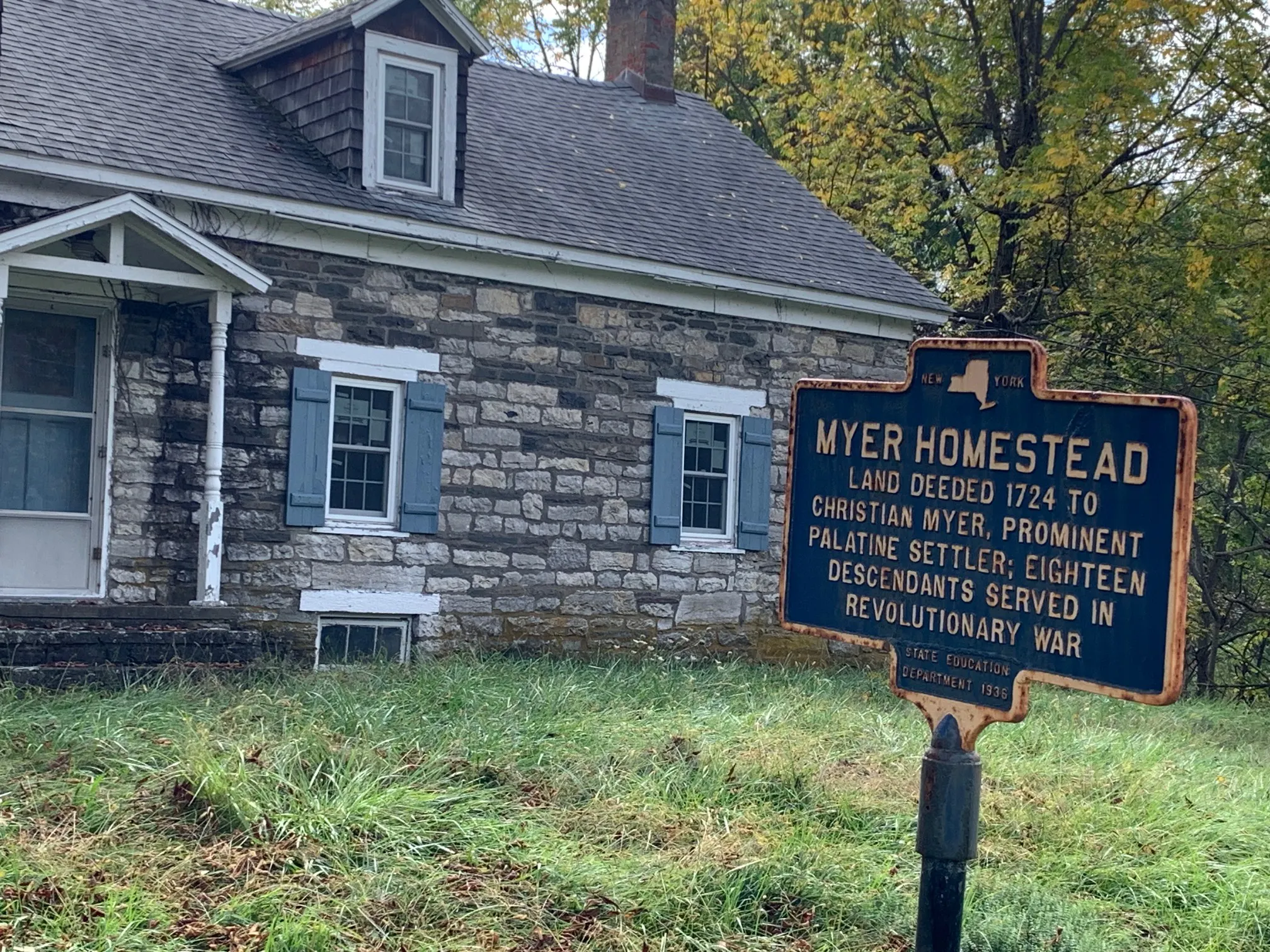 |
Land deeded 1724 to Christian Myer, prominent Palatine settler; eighteen descendants served in Revolutionary War |
1079 Kings Highway, indirectly across from Canos Recycling. |
| Mynderse House |  |
John Person, patentee 1712, built Grist Mill and est'd ferry across Esopus Creek. Deeded to daughter of Myndert Mynderse. Addition built 1743 | On Mynderse Street, 300 yard from its intersection with U.S. Route 9W. |
| National Historic Business District | 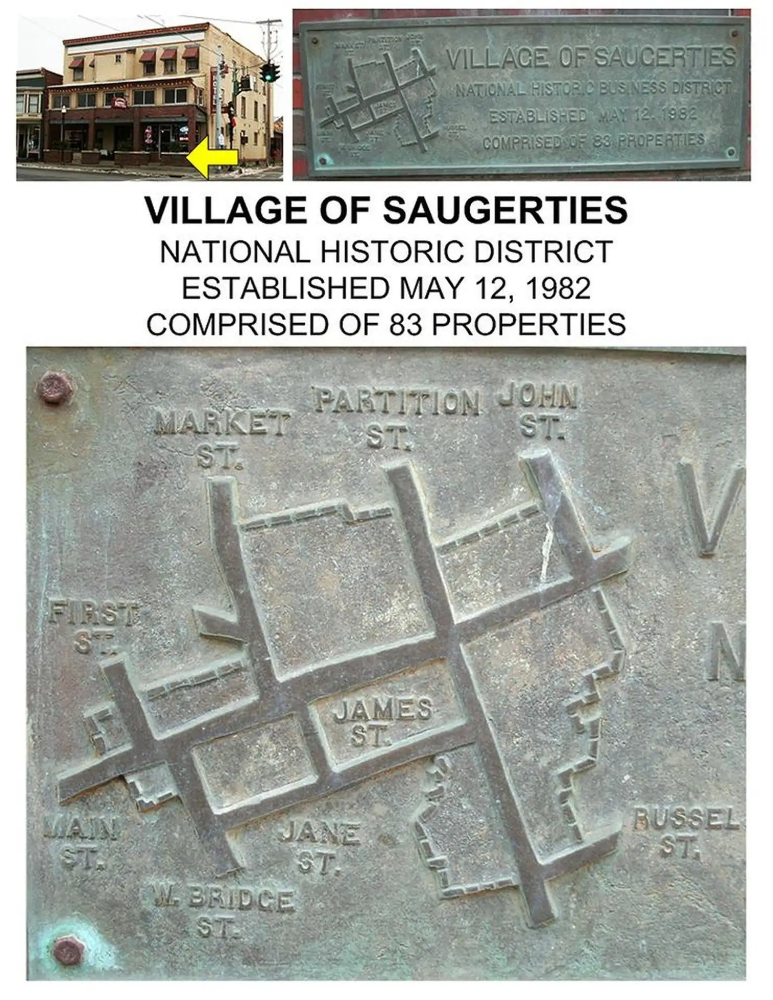 |
Village of Saugerties National Historic Business District Established May 12, 1982 Comprised of 8 properties |
Affixed to the front of the Exchange building, 207 Main Street. Corner of Main and Partition Streets. |
| Post Tavern Site |  |
Used as Patriots meeting place during Revolution. Articles of Association signed here. Religious services held here 1815-29. |
|
| Schoonmaker Homestead |  |
Elder Katsbaan Church, member of General Committee of Articles of Association. Occupied continuously by descendants. Pre-Revolutionary house. | 7 Main Street, west of where Main Street intersects with Mynderse Street. |
| Settlers Captured |  |
Settlers Captured June 18, 1780, near this spot, Peter Short and Peter Miller were captured by Tories disguised as Indians and taken to Canada. |
State Route 212, near the intersection with Baumgarten Road. |
| Snyder Farm | 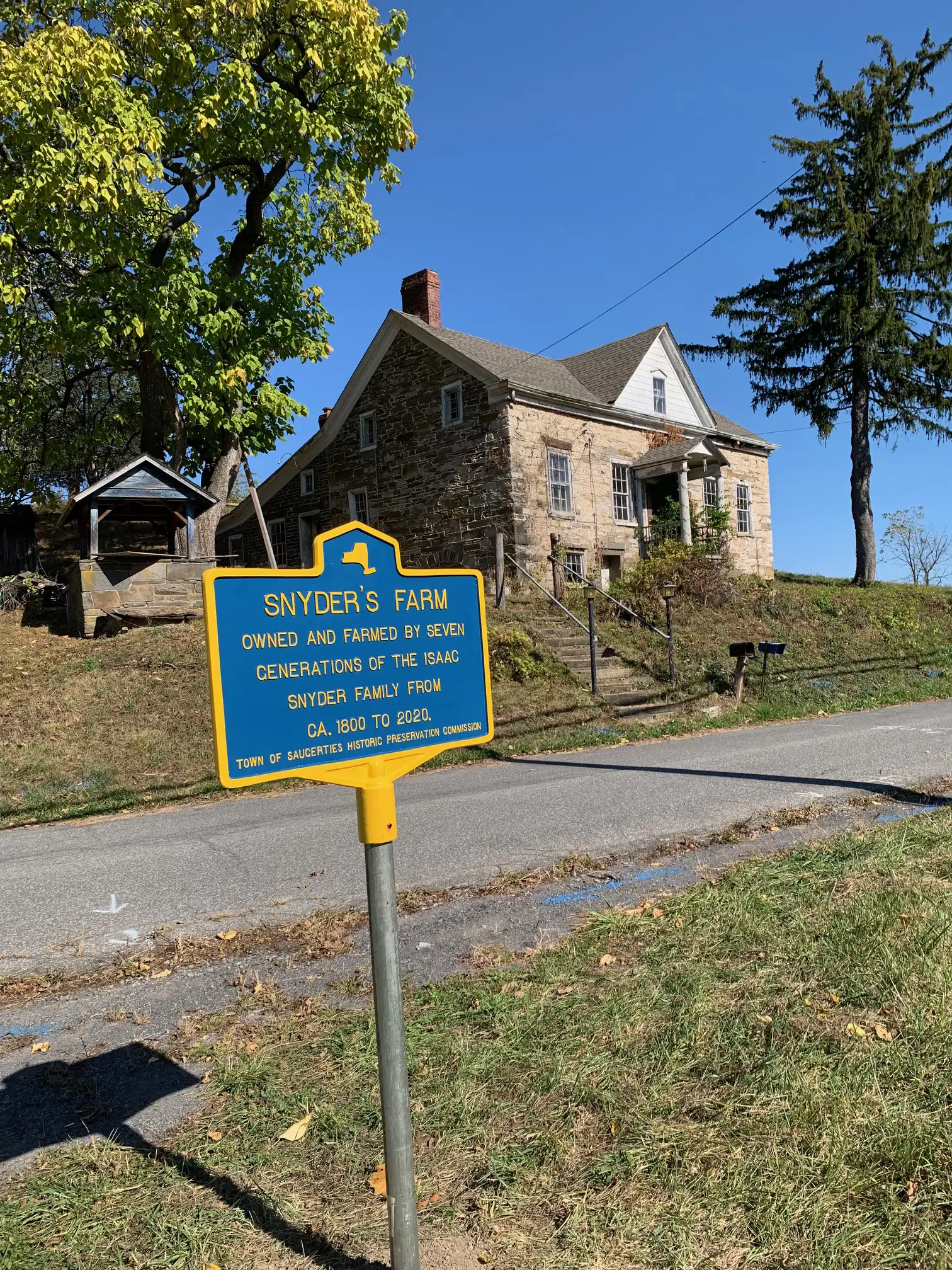 |
Snyder's Farm Owned and farmed by 7 generations of the Isaac Snyder Family from ca. 1800 to 2020. |
108 NY State Route 212. Old Route 212 spur off of the current Route 212. |
| Tavern Site |  |
Tavern Site Kept by Christian Fiero. Public meeting place during Revolution. First Town meeting held here April 16, 1811. |
North of NY State Route 32, at Katsbaan. Intersection of Old Kings Highway and Malden Turnpike. |
| Ulster County (border marker) | 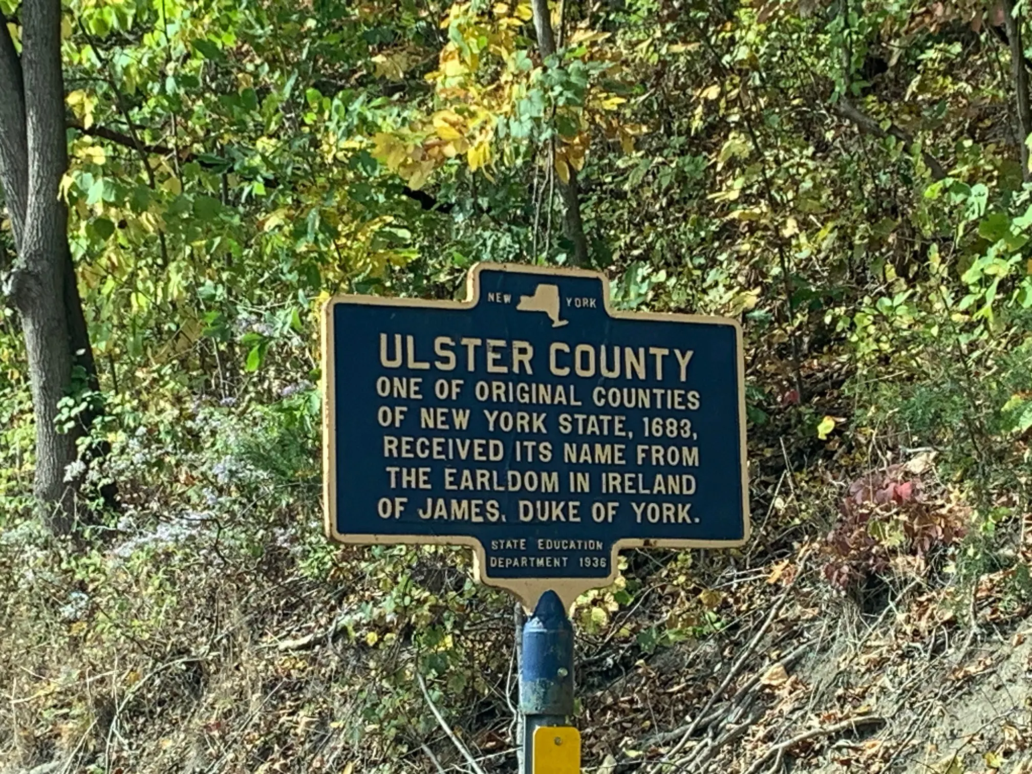 |
Ulster County One of original counties of New York State, 1683, received its name from the earldom in Ireland of James, Duke of York. |
US Route 9W, at the borderline between Ulster and Green Counties (facing southbound drivers). |
| West Camp | (photo unavailable) | Settled 1710 by Palatines from the Rhineland for Production of naval stores. Built church and school during first winter. |